Community Input needed on Transportation Safety
Published on April 24, 2026
The City of Tracy is encouraging residents to take part in shaping the future of local transportation safety by participating in two public surveys now open through May 10. These surveys accompany ongoing outreach efforts—including an appearance at the annual Earth Day celebration at the Tracy Farmer’s Market—to gather community input on planned enhancements for people who walk, bike, and travel across the city.
Two major safety initiatives are currently underway: the Active Transportation Program (ATP) – Cycle 8 and the Safe Streets and Roads for All (SS4A) program. Both programs focus on engineering upgrades designed to improve safety near schools, transit stops, neighborhood streets, and high‑traffic corridors.
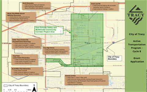
The ATP Cycle 8 project centers on the East Schulte Safety and Multimodal Community Corridor. Proposed improvements include safer pedestrian crossings, new or enhanced RRFBs and PHB beacons, protected and buffered bike lanes, sidewalk gap closures, and traffic‑calming features that make it easier and safer for residents to walk and bike in Tracy.
View Active Transportation Program (ATP) map
The SS4A 2026 Citywide Systematic Safety Improvement Project takes a broader approach, identifying priority intersections and corridors where safety upgrades—such as curb extensions, additional high‑visibility crossings, school‑area striping, and coordinated signal improvements—can reduce collisions and support emergency response needs.
View Safe Streets and Roads for All (SS4A) program map
City staff emphasize that community feedback is essential to shaping these investments. Both surveys remain open through May 10, giving residents time to review concepts, share concerns, and highlight areas where safety improvements are most needed.
Community members are encouraged to participate using the links below:
• ATP Walking/Biking Survey: cityoftracy.org/ATP-Walking-Biking-Survey
• SS4A Traffic Safety Survey: cityoftracy.org/SS4A-Traffic-Safety-Survey
The City will use survey responses, public input, and technical analysis to guide future improvements and ensure that Tracy’s streets support safe, accessible travel for everyone.